Duinen Vlieland
- Country:
- Netherlands (Kingdom of the)
- Site number:
- 2216
- Area:
- 1,484.1 ha
- Designation date:
- 29-08-2000
- Coordinates:
- 53°16'51"N 05°00'35"E
- Transboundary Site:
-
- Duinen Ameland (Netherlands (Kingdom of the))
- Duinen Schiermonnikoog (Netherlands (Kingdom of the))
- Duinen Terschelling (Netherlands (Kingdom of the))
- Duinen en Lage Land Texel (Netherlands (Kingdom of the))
- Hamburgisches Wattenmeer (Germany)
- North Sea Coastal Area (Netherlands (Kingdom of the))
- Schleswig-Holstein Wadden Sea and adjacent areas (Germany)
- Vadehavet (Denmark)
- Wadden Sea (Netherlands (Kingdom of the))
- Wattenmeer, Elbe-Weser-Dreieck (Germany)
- Wattenmeer, Jadebusen & westliche Wesermündung (Germany)
- Wattenmeer, Ostfriesisches Wattenmeer & Dollart (Germany)
Map
Photos
Overview
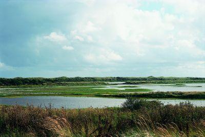
Duinen Vlieland is a small island in the Wadden Sea, characterized by an extensive area of sand dunes, conifer crops and embanked brackish lagoons important for maintaining the biodiversity in the Atlantic biogeographic region. The Site was formerly part of Ramsar Site 1252 (Waddeneilanden, Noordzeekustzone, Breebaart) which was divided into six Sites following Natura 2000 borders in 2014. The Site is of particular importance for breeding and non-breeding bird species. Some of these, such as the common redshank (Tringa totanus robusta) and Eurasian spoonbill (Palatea leucorodia), gather in particularly high numbers. The Site plays also an important role in freshwater supply and shoreline stabilization. Land use is dedicated to tourism, conservation and research. The main threats to the Site are bird disturbance by air force military training and over-exploitation of groundwater.
Transboundary designation
Administrative region
National legal designation
- National Ecological Network (NEN) - Duinen Vlieland
Regional (international) legal designations
- EU Natura 2000
Last publication date:
Download
Ramsar Information Sheet (RIS)
- NL2216RIS_2207_en.pdf
- NL2216RISformer_210608_1504_en.pdf
- NL2216_map211025.pdf