Duinen Schiermonnikoog
- Country:
- Netherlands (Kingdom of the)
- Site number:
- 2214
- Area:
- 833.1 ha
- Designation date:
- 29-08-2000
- Coordinates:
- 53°29'15"N 06°10'25"E
- Transboundary Site:
-
- Duinen Ameland (Netherlands (Kingdom of the))
- Duinen Terschelling (Netherlands (Kingdom of the))
- Duinen Vlieland (Netherlands (Kingdom of the))
- Duinen en Lage Land Texel (Netherlands (Kingdom of the))
- Hamburgisches Wattenmeer (Germany)
- North Sea Coastal Area (Netherlands (Kingdom of the))
- Schleswig-Holstein Wadden Sea and adjacent areas (Germany)
- Vadehavet (Denmark)
- Wadden Sea (Netherlands (Kingdom of the))
- Wattenmeer, Elbe-Weser-Dreieck (Germany)
- Wattenmeer, Jadebusen & westliche Wesermündung (Germany)
- Wattenmeer, Ostfriesisches Wattenmeer & Dollart (Germany)
Map
Photos
Overview
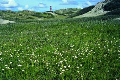
Duinen Schiermonnikoog is the smallest of the five inhabited Wadden Sea barrier islands. The Site was formerly part of Ramsar Site 1252 (Waddeneilanden, Noordzeekustzone, Breebaart) which was divided in six Sites following Natura 2000 borders in 2014. It is formed by dunes and intertidal mudflats, oak groves, conifer crops and a small freshwater lake and tidal lagoon. The Site is of international importance for European threatened species of breeding birds such as the northern wheatear (Oenanthe oenanthe) and the whinchat (Saxicola rubetra), as well as for endangered flora such as fen orchid, musk orchid and yellow centaury. The dunes play an important role in freshwater supply and shoreline stabilization. Land use is dedicated to tourism, conservation and research. The main threats to the Site’s ecological character are posed by tourism and groundwater extraction.
Transboundary designation
Administrative region
National legal designation
- National Ecological Network (NEN) - Duinen Schiermonnikoog
- National Park - Schiermonnikoog National Park
Regional (international) legal designations
- EU Natura 2000
Last publication date:
Download
Ramsar Information Sheet (RIS)
- NL2214RIS_2207_en.pdf
- NL2214RISformer_210608_1504_en.pdf
- NL2214_map211025.pdf