Fujimae-higata
- Country:
- Japan
- Site number:
- 1200
- Area:
- 323.0 ha
- Designation date:
- 18-11-2002
- Coordinates:
- 35°04'26"N 136°50'17"E
Map
Photos
Overview
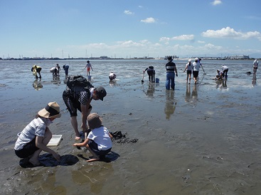
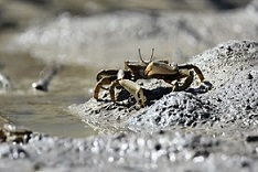
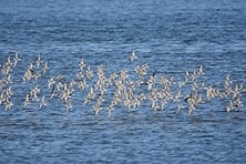
The Site is a tidal flat lying at the mouths of the Shonai, Shinkawa, and Nikko rivers where they flow into the port of Nagoya. The downstream banks of the Shonia and Shinkawa rivers, which are covered with reedbeds, and the connecting intertidal flats provide important staging areas for birds migrating along the East Asian-Australasian Flyway. The lower part of the Nikko river maintains a relatively stable flow which is suitable for freshwater ducks. About 20,000 waterbirds have been regularly recorded at the Site every year, including at least 1% of the flyway populations of northern pintail (Anas acuta), common cormorant (Phalacrocorax carbo) and great crested grebe (Podiceps cristatus). The Site is also visited by a number of endangered species, including the Nordmann’s greenshank (Tringa guttifer), the eastern curlew (Numenius madagascariensis) and the Japanese eel (Anguilla japonica). Once part of extensive tidal flats in the northern part of Ise Bay, the Site remains relatively unaltered amid widespread development of the surrounding areas. When plans to “reclaim” the entire tidal flat for a waste dumping site were abandoned by the city council, this popular site with bird watchers became a symbol of the wetland conservation movement in Japan.
Administrative region
National legal designation
- Special Protection Zone of National Wildlife Protection Area
Regional (international) legal designations
- Other international designation
Last publication date:
Download
Ramsar Information Sheet (RIS)
- JP1200RIS_2401_en.pdf
- JP1200RISformer_210818.pdf